River erosion is a key part of water erosion. Rivers are natural channels that carry water from their source to other water bodies. A water source is a geographic spot where moving water begins, such as a mountain top or a spring. The speed, behavior, and erosive power of rivers are different at various stages of the river. What rivers do to the land also depends on the type of rock that the land is made of.
Consider this illustration:
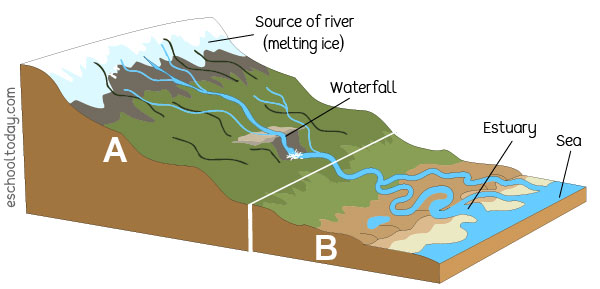
For example, from the mountain top, rivers flow very fast because the slopes of the mountains are steeper. The water is also narrower and has high erosive power. That means they can cut through the rocks on which they flow. Rapids, waterfalls, and v-shaped valleys are common along the path of rivers upstream.
Down at the foot of the mountains and where the end of the river is, (such as an estuary or the sea) the rivers are slow-flowing with lots of curves. They contain a lot of sediments that begin to settle. This means that landforms created by water erosion will be different at these two stages of the river.
Consider this illustration below:
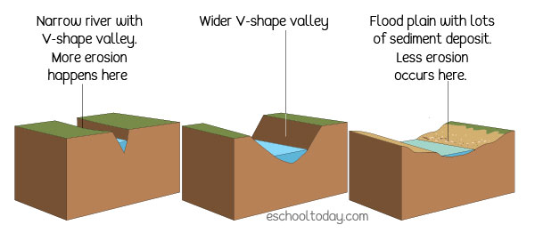
From the above, you will notice that landforms with steeper valleys, waterfalls, and gorges are more likely to form in the upper regions of highlands or mountains. This is so because the power of the river is higher and does more erosion or carving than it deposits. Landforms at the
end of rivers are more sediment deposited landforms such as moraines, flood plains, deltas, and estuaries. This is so because the rivers have lost their erosive and transporting power and are depositing the load now. A river’s load is all the stuff it carries such as fine sand, silt and clay, small tree stumps and vegetative matter, and so on.