A coastline is simply the meeting point of land and the seas or oceans. It includes all the beaches, cliffs, capes, caves, bays, and estuaries that line up at the end of the land. These features may all be located close to each other on a coastline.
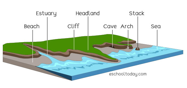
The illustration below shows a small stretch of a typical coastline, where land meets the sea. Notice how there can be many smaller landforms all lined up along a coast.
Coastlines change with time. When sea levels rise and fall, coastlines are re-shaped. Constant erosion or sediment build-up also changes the shape and form of coastlines. New features such as stacks and caves are formed, while older physical features break up.
*The coastlines of the world’s continents measure about 312,000 km (193,000 miles).
Coastlines are formed in many ways — the deposit of sediments carried by ocean currents and rivers entering the sea, and also by erosion by waves. Rugged and rocky coastlines are mostly formed by erosion. Sandy beaches, sedimentary and shallow coastlines, are formed from sedimentary deposits. Earth or tectonic movements can also push up new landforms or spill out new lava from nearby mountains, creating new coastal features.
Examples of some coastlines include:
- 1. Halong Bay, Quang Ninh province of Vietnam. It is famous for its breath-taking mix of limestone, rocky, tall islands, caves, and vegetation with fishermen living in floating villages. It was designated as a UNESCO World Heritage Site in 1994.
- 2. Big Sur, California, USA. This is a 90-mile stretch of beautiful coastline between Carmel to the north and San Simeon (Hearst Castle) to the south.