An island is a piece of land surrounded by water. They can be small or large. Some islands are formed on the continental shelf (very close to the coastline), and they are continental islands. Others are formed far from the continental shelf (in the ocean), and they are called oceanic islands.
An island on a river is called ait or eyot. It is common to see many small islands in one location, such as the 115 Islands of Seychelles, off the coast of East Africa. Such a collection is known as an archipelago. Other names of islands are cays, islets, or keys.
The largest island is Greenland.
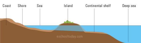
The illustration below shows a basic island on the continental shelf.
Islands are formed in many ways.
Oceanic island or Volcanic islands:
Volcanic eruptions in the sea can create new lands by piling up lava and solidifying in the sea. Tectonic plates can also cause the seabed to folded and push new land up to the water surface.
Continental islands:
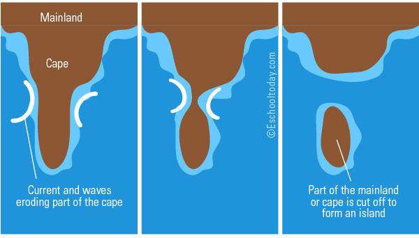
Continental islands are formed when parts of the mainland are broken off or eroded by wave action, leaving a piece of land on its own.
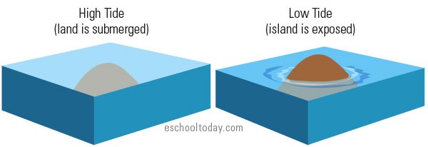
Tidal islands:
Changes in the sea level can also expose islands. These are called tidal islands, such as the Mont Saint-Michel in France. Here is an illustration of a tidal island.
Barrier islands:
Currents and waves can also pile up sediments and sand in one location and with time, build up into an island. These are usually low-lying islands, running parallel to the mainland, and with mostly sand as the landmass. This type of island is called a barrier island. The Ocean City island in Maryland USA is a great example.